
Compressive Seismic - Survey Design QC
Compressive Seismic surveys all look similar. How can we compare different designs to determine which is the best (without acquiring each one)?
Mutual Coherence Maps (MC-maps) U.S. Patent No. 10317542
In-Depth's patented MC-maps mathematically quantify how suitable a survey is for reconstruction at the design stage. It does this by measuring the normalized orthogonality of the singular vectors at each grid location (Jiang, 2018). There is some mathematical gymnastics involved, but the core result is that MC-maps can help predict how well a survey will reconstruct. MC-map values range from 0 to 1: the lower the value, the less spatially-aliased the data, and the better the reconstruction result.
Conventional Grid
The textbook receiver layout below is perfectly regular. The overlaid MC-map indicates that such a conventional acquisition expectedly yields a high degree of spatial aliasing (Nyquist-Shannon) and thus cannot be reconstructed well.

2D MC-map of a conventional grid acquisition design. Red (MC = 1) indicates areas of maximally poor reconstruction; blue (MC = 0) indicates stronger reconstruction.
Randomized Jittered Design
The MC-map below shows a randomized design created in an off-the-shelf survey design software using a jittered approach, where individual nodes are shifted by random distances in multiple directions under constraints. The resulting MC-map has improved considerably, but the values are not low enough to be considered fully optimal.
While this jittered design significantly reduces spatial aliasing compared to conventional designs, jittered approaches can be more difficult to acquire in the field, and they sometimes require special treatment when processing in order to account for irregular spacing in two dimensions.

2D MC-map of a randomized jittered acquisition design. Red (MC = 1) indicates areas of maximally poor reconstruction; blue (MC = 0) indicates stronger reconstruction. The randomized jittered design is clearly superior to a conventional design.
Randomized Gridded Design
The gridded design below is another variation of a random design where it randomly shifts each receiver location, but only by specific increments in one direction, meaning every resulting point belongs to a point on a finer grid. The resulting MC-map QC shows that this type of design has extreme variability, with many locations that contain even worse levels of spatial aliasing than the conventional design.
Constraining the final design to a regular grid does have many benefits in both acquisition and processing, but it is very difficult for a random design to sufficiently reduce spatial aliasing under this constraint. The resulting reconstruction may be poor and unreliable.
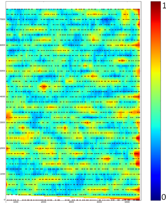
2D MC-map of a randomized gridded acquisition design. Red indicates poor reconstruction; blue indicates stronger reconstruction. The randomized gridded design has many peaks of maximally poor reconstruction scattered throughout the survey.
Optimized Gridded Design
The design below uses In-Depth's patented regularly-indexed optimized CS design. This approach uses a grid, retaining the acquisition and processing benefits of regular grid spacing, but iteratively minimizes the 2D mutual coherence throughout the survey to obtain a design highly suitable for reconstruction. The resulting MC-map shows a much lower level of spatial aliasing throughout the survey than either form of randomized design, despite each node belonging to a regular subgrid. This reconstruction is likely to be ideal, and the regular grid spacing makes for easy acquisition and processing.

2D MC-map of In-Depth's Regularly-Indexed Optimized design. Red indicates maximally poor reconstruction; blue indicates stronger reconstruction. This optimized design minimizes spatial aliasing while retaining the advantages of a regular grid.
Conclusion
Seismic acquisition is extremely expensive and time-consuming. Before going out in the field, we need to be absolutely certain that our survey design produces seismic data meeting our imaging objectives. 2D MC-maps are an essential tool to help guarantee that a Compressive Seismic (CS) survey design will produce data that can be adequately reconstructed.
