
Bin Reduction and EPOCS Recon for Legacy Surveys
In-Depth Proprietary Technology
Invented by IDCS President Dr. Tao Jiang, EPOCS (Extended Projection onto Convex Sets) is a fast and powerful reconstruction algorithm which can regularize survey grids, deblend simultaneous-source data, and fill missing traces.
As a sparse solver, EPOCS is uniquely suited for reconstructing data acquired using Compressive Seismic (CS) Acquisition designs, which use irregular grid spacings to capture a wider range of spatial frequencies in the data. However, all seismic surveys have some degree of irregularity when acquired, especially legacy datasets with large permit holes and complex terrain.
With EPOCS, these problematic irregularities become assets—allowing legacy datasets to be beautifully reconstructed.
Figure 1 compares traditional 5D reconstruction to EPOCS on a legacy dataset riddled with obstacles and permit holes. EPOCS hugely improves event continuity and signal-to-noise compared to traditional reconstruction methods.
In-Depth’s Compressive Sensing technology can also be used for EPOCS Bin Reduction, which takes advantage of the inherent randomness of legacy acquisitions to reduce their bin sizes to the natural limit based on the level of spatial aliasing in the data.
Fig. 1. Comparision of traditional 5D and EPOCS reconstruction of land data with extreme permitting holes. EPOCS (right) dramatically improves event clarity and continuity around complex structure, completely filling large permit holes without leaving visible artifacts. In contrast, 5D reconstruction (center) leaves obvious artifacts and footprint while being unable to fill the whole survey. (Publication link)

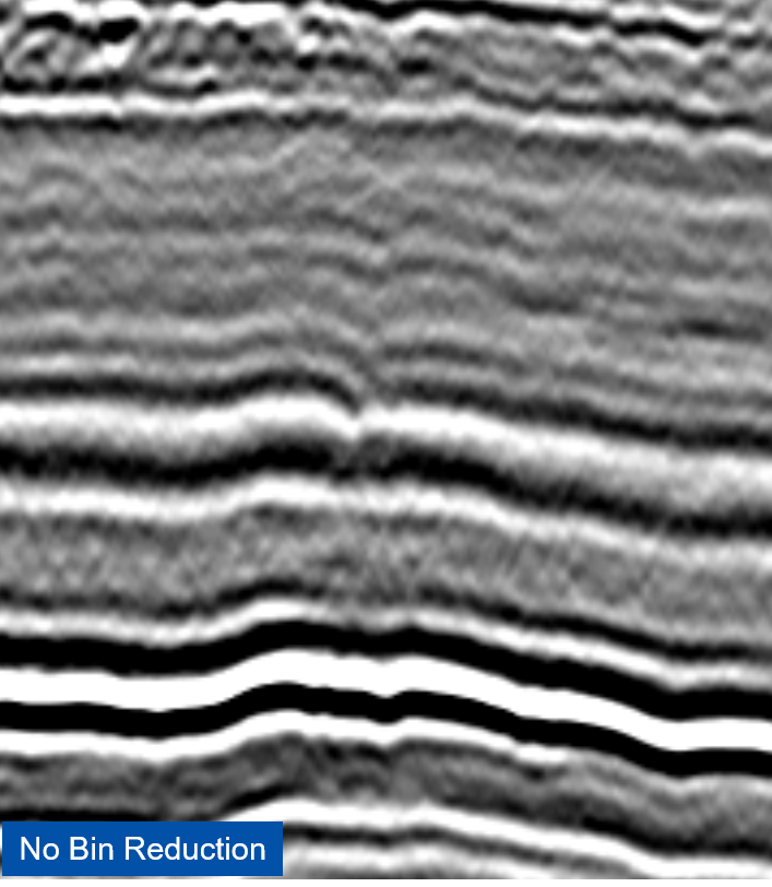
Fig. 2. In-Depth’s proprietary EPOCS-based Bin Reduction makes use of Compressive-Seismic-like irregular legacy acquisition designs to reconstruct the data to a finer bin grid. The size of the potential reduction depends on the level of spatial aliasing in the acquired data, which we measure using our patented 2D Mutual Coherence (MC) map measured at various bin sizes. (Publication Link)
Fig. 3. In-Depth’s patented 2D Mutual Coherence (MC) map comparison for identical surveys calculated at two different bin sizes, 45m x 45m and 30m x 30m. Because the mutual coherence is still relatively low (ideally, MC = 0, indicated by dark blue) using a 30m bin size, a 33% Bin Size Reduction from 45m to 30m is viable on this dataset.

Fig. 4. Brute stack comparision of legacy 5D interpolation (left) and EPOCS reconstruction (right) of Chevron land data in the Appalachian basin with permitting holes, natural obstacles, and highly variable fold. EPOCS produces far superior event clarity and continuity compared to legacy while properly reconstructing complex overlapping diffractions and filling shallow gaps. (Publication Link)